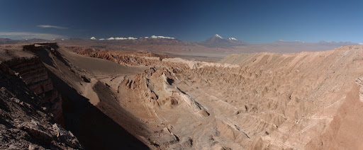
Sunrise before climbing Dune 45
May 282011
Driving out on to the Salar at dawn.

We woke up at some crazy hour again on the fourth day of the tour so that we could see the sunrise over the Salar de Uyuni.  You can read all about the Salar over at Wikipedia but the basic idea is that it is huge plane of salt (4000 mi²) that is incredibly flat (less than 1m elevation difference across its entire area).  During the wet season the Salar is flooded with a few inches of water.  This was the case when we visited and I have to say that driving out on a mirror-like plane of water at dawn was pretty cool.

We first drove to a salt hotel out on the Salar where we could mill about and take in the sunrise.  It was cold, below freezing without a doubt.  While we were waiting for the cook to prepare breakfast, we enjoyed watching the sunrise and started to take some crazy photos the Salar is known for.  The lack of recognizable objects (trees, cars, etc) in the photos allows you to play all sorts of fun perspective tricks with the camera.

After breakfast, we drove further out on the Salar to get away from other tour groups.  Our guide then helped us take all sorts of fun photos.  Some of the more ambitious backpackers had brought props all the way from home for the occasion but we had to make do with what was on hand.  Fortunately, the guide had some good ideas!  Be sure to check out the gallery below for many more.

A bunch of gringos out making fools of themselves in the middle of the salt flats.

Two hours into our ”fotos locas” shoot, we packed up and headed for a couple of other sights around the flats.  We stopped in one area where salt miners were working away to harvest salt and in another area where some of the Salar’s trapped brine bubbles to the surface (the Ojos del Salar).  Finally the tour wrapped up with a quick visit to Uyuni’s train cemetery where dozens of turn-of-the-century steam trains have found their final resting place.

All in all, we really enjoyed our time on the four day tour of Bolivia’s southwest.  Our traveling companions were great, the guide was excellent, the driving was responsible, and the food was delicious.  At only $160 per person it was an absolute bargain and we would strongly recommend Tupiza Tours to others!  Next up on the blog, the cities of Potosí and Sucre.

Slowing sinking into the desert.
Southwest Circuit Day 4
Driving out on to the Salar at dawn.
A salt condor!
A salt condor!
A duel
A duel
Amy having some mate
A Pez dispenser
A Pez dispenser
The vegetarian eats the omnivores
The evolution of man.
A bunch of gringos out making fools of themselves in the middle of the salt flats.
Our guide was quite skilled at creating fotos locas.
Ojos del Salar
Ojos del Salar
Salt mining (for human consumption)
Some of the Salar is flooded at this time of year.
The last stop was the train graveyard near Uyuni
Slowing sinking into the desert.
Our final meal on the tour.


May 262011
Laguna Colorada
Laguna Colorada

Day 3 started with a visit to Laguna Colorada a short 10km from where we stayed the night before.  The laguna is one of the largest flamingo habitats in the world and three of the six species of flamingos feed here.  Like just about everything else on this tour, the lake sits at high altitude (4,270m).

James's Flamingos
James’s Flamingos

We spent about an hour marveling at the flamingos and the nonstop chatter with one another.  There are three distinct species that live in this lake but they can be tricky to tell them apart.  To be honest, I am not really sure which of the three we saw.  One group was definitely the James’s Flamingo but who knows about the other two types (Chilean and Andean).

After Laguna Colorada we drove to the overly famous Arbol de Piedra.  It’s a big rock that has been eroded away at the bottom and looks vague (very vaguely) like a tree.  Like all the other tourists, we stopped and took photos wherein we pretend that it is about to fall on us.

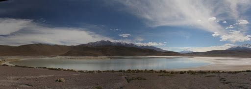
Driving northward from the Arbol de Piedra, we passed a string of five high-altitude lagunas.  I tried to take panoramic photos of them but only three of them worked out.  By the fifth lagoon everyone in the jeep had that “oh boy, another laguna…” sarcasm about them but, in retrospect, they were all incredibly spectacular.  One tends to lose track of how incredible the landscape really is when faced with it day in and day out.

Laguna Ramaditas
Laguna Ramaditas
Laguna Honda
Laguna Honda
Laguna Cañapa
Laguna Cañapa

Our lunch stop was in another rock-littered valley, conveniently named the Valle de las Rocas, that was also home to a bunch of viscacha.  Chasing them about to get good photos proved to be quite a challenge.

Another viscacha!
Another viscacha!

A couple hours after lunch we rolled into the town of San Cristóbal.  We stopped right in the center and had a brief walk around.  My first impression of the place was “Civilization!  My money is actually good here…I could BUY something if I wanted to.”  I guess that is pretty normal after three days out in the middle of nowhere.  San Cristóbal is a mining town and is home to Bolivia’s largest mine.  Workers at the mine work 12 hour shifts for three months straight (no weekends off) and then get two weeks of leave.  A hard life that must be.

Nothing spells Bolivia quite like loading a tractor trailer with salt using a shovel.

Colchani, a small town with about 500 people, was our resting place for the third night.  The town is located on the shore of the Salar de Uyuni and seems to eek out its existence on tourist dollars and salt production.  Our accommodations for the night were in a lodge made almost entirely out of salt.  The walls were salt, the floor was salt, and the beds were salt.  Pretty weird.  The main downside was that there was no running water which meant we were on our way to our fouth showerless day!

Afternoon tea with salt
Southwest Circuit Day 3
Our digs for the second night of the tour
Laguna Colorada, dotted with flamingos
Laguna Colorada
Laguna Colorada
Laguna Colorada
Laguna Colorada
Flamingo footprints
Flamingo footprints
James's Flamingos
James’s Flamingos
The overly-famous arbol de piedra (tree of rock)
Laguna Ramaditas
Laguna Ramaditas
Laguna Honda
Laguna Honda
Laguna Charcota
Laguna Charcota
Laguna Hedionda
Laguna Hedionda
Laguna Cañapa
Laguna Cañapa
Valle de las Rocas
Valle de las Rocas
Another viscacha!
Another viscacha!
This is the “condor rock.”  I like the real ones better.
This is the “condor rock.” I like the real ones better.
A brief stop in a real town!  San Cristobal
A brief stop in a real town! San Cristobal
Lots of salt in these parts
Nothing spells Bolivia quite like loading a tractor trailer with salt using a shovel.
The crazy Dutch pig whisperer showing off his skills.
Afternoon tea with salt
Our room at the salt lodge.  Walls, floor, beds and headboards all made of salt.
Our room at the salt lodge. Walls, floor, beds and headboards all made of salt.

Desierto de Dali
Desierto de Dali

Day 2 started off nice an early.  4:30 or thereabouts, definitely within what is called the “madrugada” in Spanish.  None of us slept well that night thanks to the well-below-freezing temperatures and the 4,200m of altitude.  I slept in long-johns, a tshirt, a long-sleeve shirt, my fleece inside of a sleeping bag under three heavy wool blankets and I was still pretty cold.  Our driver loaded our stuff on top of the jeep while we chowed down on some breakfast.

We pulled out of San Antonio de Lipez around 5AM and headed for the ruins of a deserted town.  Along the way we had to forge a number of frozen-over streams.  The old mining town was one of the many places where the Spanish forced the Incans to dig for silver.  The story has it that the town is now haunted.  Visiting the town in the pre-dawn twilight gave it an even creepier feel.  The only remaining resident is this nice fluffy viscacha.

A viscacha!
A viscacha!

We pressed on through a 4,855m mountain pass with a great view of Lago Morejon and Volcano Uturuncu (6,0008m).  Frost on covered the ground that was shadowed from the sun by the small hearty shrubs that manage to flourish at this altitude.  Walking just a few yards on level ground proved to be enough to make us winded.

We descended from the pass and crossed a few more rivers – one of them was quite deep and I was happy that the door seals on our Toyota were in good shape!  Temperatures remained quite low but the intense sunshine made being outside much more bearable.  We visited another high-altitude lake where borax mining was underway.

Passing by the settlements of Quetena Chico and Quetena Grande, we entered the Eduardo Avaroa National Reserve of Andean Fauna.  The  lunch stop was at some hot springs at the aptly named Aguas Calientes.  We could bathe if we wanted although I just put my feet in the water.   Once lunch was finished we crossed the Desierto de Dali and reached the shore of Laguna Verde.  The lake is free of wildlife because of the naturally-occuring arsenic in its waters.  The element gives the lake its color.  The stop at Laguna Verde was the southernmost point on our tour and we were just a short distance from San Pedro de Atacama, Chile where we had traveled a few days prior.

Laguna Verde with Volcan Licancabur (5950m) behind

Heading back north we made a stop at Geisers Sol de Mañana, a geyser field just below 5000m altitude.  Most of the activity is steam vents but there are also a few boiling mud pots to be seen (if you dare go close enough).  The highest point on the tour was just a little further ahead at 5,000m (16,400ft) and we got there just in time to see another tour jeep broken down on the road.  Despite the fact that it was a competing company, we stopped (along with seven others) to lend a hand.  These guys definitely work together when things go wrong!

We made it to the village of Huaylljara just before sunset and prepared for another cold night.  Dinner was pique macho, a traditional french-fries-covered-in-everything-unhealthy dish that hit the spot.  Afterwards, we all competed around the camp’s single wood stove while we learned a new card game from our Dutch friends.  And that was that, another great day in Bolivia.

Laguna Colorada
Laguna Colorada
Southwest Circuit Day 2
Incan ruins
Incan ruins
A viscacha!
A viscacha!
Morning frost
Morning frost
Forging rivers
Forging rivers
Middle of nowhere
Middle of nowhere
Hot springs
Hot springs
Lunch at the hot springs.  Meat balls, pasta, veggies and salad
Lunch at the hot springs. Meat balls, pasta, veggies and salad
Driving across the Desierto de Dali
Desierto de Dali
Desierto de Dali
Laguna Verde with Volcan Licancabur (5950m) behind
When a truck breaks down, all the tour operators chip in to help.
Laguna Colorada
Laguna Colorada
Traditional Bolivian food for dinner: Pique (french fries topped with meats and eggs).  There was veggie pique for Amy as well!
Traditional Bolivian food for dinner: Pique (french fries topped with meats and eggs). There was veggie pique for Amy as well!

May 222011
Loading up in Tupiza.  There were four of us, the guide/driver and his wife the cook.
Loading up in Tupiza. There were four of us, the guide/driver and his wife the cook.

Most tourists to Bolivia come to see the enormous Salar de Uyuni, the world’s largest salt flat.  Many of my friends who have visited have told stories about excellent “multi day Salar tours” that let you experience the flats and the surrounding landscape.  What neither of us realized is that these tours are mostly about the surrounding landscape and you really only spend one day on the Salar (though it is the highlight).

There are loads of companies offering tours of the Salar and you can start these tours from any number of places in Chile and Bolivia (the flats are near the border).  We had heard mixed things from other travelers about the quality of these tours and we quickly arrived at the conclusion that paying a little extra was well worthwhile.  Tupiza Tours and La Torre Tours quickly surfaced as the leaders for tours originating in Tupiza, Bolivia.  We ended up booking the 4 day, 3 night tour with Tupiza Tours for about $160 per person (included transport, food and accommodation).

Vicuñas
Vicuñas

Logistics for the tour was as follows.   We traveled in a group of four plus a driver/guide and a cook.  In our case, the driver and cook were a very pleasant husband and wife team.  We opted for a Spanish tour, though English ones were available for an extra fee.  The company paired us up with a couple from Holland, also in their late 20′s, and we turned out to be a great match.  Transportation was in a Toyota Land Cruiser with a third row of seats and our backpacks were loaded with the cooking gear and extra gasoline on the roof.  Accommodations, though rustic, were completely adequate.  We stayed in small villages along the way where they had beds, electricity, and shelter (though not always running water).  Total driving distance for the four-day trip was about a thousand kilometers and 90% of that is off-road.

Lunch time somewhere in the middle of nowhere.

The first day of our tour took us from Tupiza to San Antonia de Lipez.  Shortly after we left Tupiza we checked out some nice read rock formations (iron content, I think they said) and then started our climb into the mountains.  The average altitude on the four-day tour was 4,200m (13,800ft) and it wasn’t long before we were cruising away at altitude.

Shortly after we got up into the mountains we spotted a group of a dozen condors.  As it turned out, they were all feasting away on a vicuña carcass!  We stopped for a while and watched them watch us.  After the condors we found a nice place for our lunch in the middle of a large dry riverbed.  The highlight of the meal for me was some llama tamales.  At the first meal the cook seemed a bit surprised that Amy was a vegetarian despite the fact that we had explicitly told the office where we booked.  Apparently they neglected to relay this on to the cook!  Fortunately, our cook was able to adapt to this request and later meals in the tour were more vegetarian-friendly.

San Antonio de Lipez, our stop for the first night.  (4,200m)
San Antonio de Lipez, our stop for the first night. (4,200m)

In the afternoon we stopped in to visit the village of San Pablo de Lipez as well as a few nice mountain vistas along the way to San Antonio de Lipez, our stopping point for the day.  We had an afternoon tea/coffee/mate break when we arrived and finished just in time to see the first snowfall of the year.  An excellent dinner was served a short while later we called it an early night (8PM!) due to the altitude and having to get up at some crazy time the next morning.

Our first dinner with our new friends from Holland
Southwest Circuit Day 1
Loading up in Tupiza.  There were four of us, the guide/driver and his wife the cook.
Loading up in Tupiza. There were four of us, the guide/driver and his wife the cook.
The rock formations of Palala just outside of Tupiza
Lllamas
Lllamas
Vicuñas
Vicuñas
A lizard!
A lizard!
Lunch time somewhere in the middle of nowhere.
Tamales with llama meat.  Tasty!
Tamales with llama meat. Tasty!
It was a bit windy on this ridgeline.  I think they called it the Paso de Diablo.
It was a bit windy on this ridgeline. I think they called it the Paso de Diablo.
We interrupted lunch (a vicuña carcass) for a group of a dozen condors.
The village of San Pablo de Lipez
Vicuñas
Vicuñas
San Antonio de Lipez, our stop for the first night.  (4,200m)
San Antonio de Lipez, our stop for the first night. (4,200m)
A storm was rolling in when we arrived.
The first snow of the year in San Antonio de Lipez
Drying adobe bricks
Drying adobe bricks
Afternoon tea just after arrival.
Our first dinner with our new friends from Holland
Not a bad spread for a tour out to the middle of nowhere!

Victory!
Victory!

Getting across the border into Bolivia was easy enough.  We walked to the border just after sunrise and waited around for about half an hour while the authorities on the Argentine side dealt with some families that were crossing with children.  Once we were stamped out off Argentina we walked 50 yards across the bridge and presented ourselves at Bolivian immigration.  There was no queue when we arrived and they gladly accepted our $135 visa fee and, in return, put some shiny stickers in our passports.  Nationals of most countries (including places like Yemen) don’t need to pay for visas to Bolivia, however, US policies towards tourists have led Bolivian towards a policy of reciprocity.
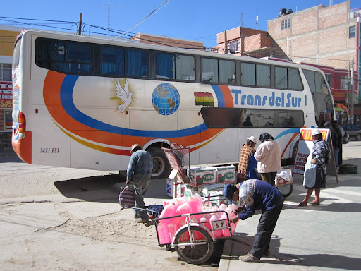
Our first Bolivian bus.  Villazón to Tupiza.
Our first Bolivian bus. Villazón to Tupiza.

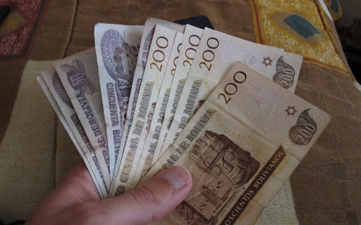
The Bolivian border town of Villazón was not nearly as seedy as we were led to believe.  The town was actually quite clean, had a nice square and lively commercial activity.  Our first goal was to withdraw some Bolivianos from the town’s one and only ATM.  I requested 2,500 Bs from the machine (about $300) and after the usual whirling noises it dispensed my card and a receipt but no cash.  Doh!

There were some bank employees standing around waiting for the bank to open and they advised Amy that she should be able to withdraw 1,000 Bs from the machine without a problem.  There was some talk of the machine only being able to dispense ten bills at a time.  She gave it a try and the same thing played out – no cash.  By this point the bank was open so we went in and Amy spoke to the supposed manager of the bank.  In a very couldn’t-care-less manner he told her that they knew the ATM was broken yet there was no sign on the machine.  Perfect.
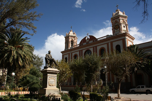
Tupiza's central plaza
Tupiza’s central plaza

Time for the backup plan.  Good old US dollars.  We hit up a couple of cambios (currency exchange shops) before we found one that would accept the two wrinkled $20 bills that I had handy.  They gave me a half-decent rate and we had enough money to get out of Villazón on the bus.
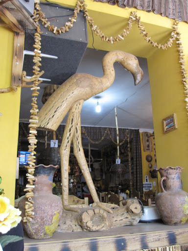
Awesomely bad decorations at a just plain bad tourist restaurant in Tupiza.  Yup, that is a flamingo made of cactus wood.
Awesomely bad decorations at a just plain bad tourist restaurant in Tupiza. Yup, that is a flamingo made of cactus wood.

The drive to Tupiza is only about 60 miles but it takes about three hours thanks to the crappy roads.  Frustratingly we drove alongside of a beautiful paved highway most of the way but none of the bridges were complete.  We are definitely in Bolivia now!  The scenery was interesting through and we made it to Tupiza on time.
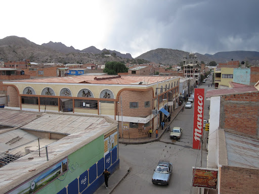
The main drag of Tupiza

After getting to Tupiza we spent the better part of a day working on the money situation.  The first step was to get in touch with our banks about the ATM withdrawals in Villazón.  Sure enough, both has been debted from our account so we were (and still are) around $440 in the hole.  Both of our banks have opened investigations into the matter so hopefully we will see the money back one day.

Tupiza doesn’t have a single ATM machine that accepts foreign cards.  Tourists have three options: 1) exchange dollars, 2) have a local bank pull a cash advance against your VISA or MC or 3) cash travelers checks.  We explored all three options and eventually decided on the cash advance.  Cashing the travelers checks turned out to be an incredible ripoff at 18% away from official rate.  We had plenty of US dollars but we wanted to hold those for emergencies.

Processing the cash advance also turned out to be a pain.  Despite placing travel notices on our accounts the cash advance transactions were denied at the bank.  After a handful of expensive phone calls back to the states (there are no pay phones through which you can call collect!) we had the issues sorted out with the bank.  When it was all said and done, we got some cash from bank within about 5% of the official rate including all the fees.  It took a day and a lot of running back and forth between phone centers, our hotel, and the bank but we got it all sorted out.  Not a smooth start to our time in Bolivia, fortunately things got much better.

WARNING TO OTHER TRAVELERS:  When the guidebook says to bring cash, it means it!  Brings lots of crisp and new US notes to avoid hassles at dinky border towns.

Boliviano Blues
Our first Bolivian bus.  Villazón to Tupiza.
Our first Bolivian bus. Villazón to Tupiza.
I sure hope this thing fits!
Tupiza's central plaza
Tupiza’s central plaza
Awesomely bad decorations at a just plain bad tourist restaurant in Tupiza.  Yup, that is a flamingo made of cactus wood.
Awesomely bad decorations at a just plain bad tourist restaurant in Tupiza. Yup, that is a flamingo made of cactus wood.
Breakfast at Hotel Mitru
The main drag of Tupiza
Not a bad place to relax before the four-day trip into the wild.
Victory!
Victory!
My first fried chicken in Bolivia.  They love it!
My first fried chicken in Bolivia. They love it!

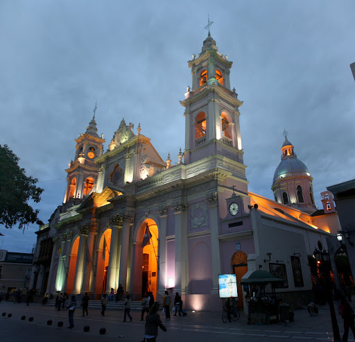
The whole reason for coming back to Argentina was to visit the far northwest provinces of Salta and Jujuy.  We started in Salta and worked our way northward to the Bolivian border.  Salta was a fairly typical large Argentine city.  It has a nice central plaza, some popular pedestrian malls and ample treats to snack on.  We spent a few days there just taking in the city and its sights.  One highlight was the Museo de Arqueología de Alta Montaña de Salta which displays Incan artifacts including three frozen mummies that were discovered on the summit of a nearby volcano.  Many other  Incan mummies have been discovered but the ones on display in Salta are the only ones preserved in low-pressure and sub-zero temperatures.  Photography is not allowed in that museum so you will just have to visit Salta to see them.

Salta’s food scene was pretty entertaining and surprisingly different from what we saw further south in the country.  For lunch our first day I tucked into a nice big bowl of locro pulsado which is a corn soup with various types of meat and potatoes.  There is also a thriving street food scene in Salta.  Pochoclo (sweetened popcorn) is certainly the king of street snacks but we also saw candied nut vendors, hotdog-encased-in-pancake-batter vendors (don’t ask) and juice vendors.  There was no problem keeping ourselves fed in Salta.

Locro: a corn and meat soup

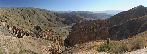
From Salta we headed north to Tilcara.  This was supposed to take about three hours on the bus but we ended up killing a full day thanks to the Argentine equivalent of labor day.  Argentines and their holidays…  Tilcara is a small town at the southern end of Argentina’s Quebrada de Humahuaca.  Quebrada is the Spanish term for a steep valley or ravine and, in this case, the geography gives the place an abundance of water for farming.

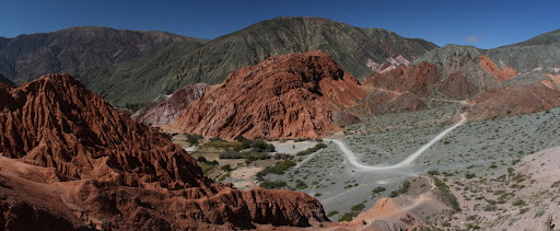
Purmamarca and its famous colored hillside

The main attraction in the Quebrada are the colorful mountains that surround the valley.  Purmamarca, a small village about 30 minutes from Tilcara, has a particularly famous “hill of seven colors” that overlooks the town.  We popped in for half a day and had a look around.

A short hike outside of Purmamarca

From Tilcara we made a one-day side trip to the remote village of Iruya (population ~1000).  The road into Iruya, called the Obra del Condor, is one crazy mountain road.  It ascends gradually to over 13,000ft before plunging through dozens of switchbacks into the valley.  The town itself is “muy tranqillo” and I believe that donkeys outnumbered cars in the streets.  Smarter donkeys were found napping in the shade under the new pedestrian-only suspension bridge which connects the two halves of the town.

Iruya, Argentina
Iruya, Argentina

After one night in Iruya we hopped a bus back to Humahuaca (bags on the roof, of course!) and made a quick connection to La Quiaca on the Argentine-Bolivian border.  We had heard that is best to get an early start at crossing into Bolivia so we wanted to get as close as possible.  More on that adventure in the next post.


Northwest Argentina
Lots of fruit to choose from at Salta's market
Lots of fruit to choose from at Salta’s market
A very enthusiastic pizza vendor at Salta's central mercado.
A very enthusiastic pizza vendor at Salta’s central mercado.
My very first humita!
The central plaza in Salta, surrounded by citrus trees
One of Salta's pedestrian streets
One of Salta’s pedestrian streets
Pochoclo con miel: Sweetened popcorn, a favorite snack of Salteños and Amy
Locro: a corn and meat soup
The place to eat in Salta
Dog that joined us while we enjoyed a coffee in the plaza.
Hot dog vendors are also everywhere in Salta
Purmamarca and its famous colored hillside
A short hike outside of Purmamarca
Amy insisted that I pose like a cactus
Who needs barbed wire when you've got a bunch of cacti on hand.
Who needs barbed wire when you’ve got a bunch of cacti on hand.
The wood of a cardón cactus
A cactus with moss growing on it.
Nice view from our room in Tilcara
Waiting on the bus and having a staring contest with this guy.
The start of the crazy road into Iruya.
Lots and lots of switchbacks.
A great view just outside our room in Iruya.  Also a good place for drying laundry!
A great view just outside our room in Iruya. Also a good place for drying laundry!
Our favorite dog in Iruya.  Amy named him Banana because he wouldn't eat the banana she gave him.
Our favorite dog in Iruya. Amy named him Banana because he wouldn’t eat the banana she gave him.
Home cookin: lentil stew and big bread
Somebody likes belly scratches
Iruya, Argentina
Iruya, Argentina


Paso Jama

Argentina, Chile Comments Off
May 162011

Before heading north to Bolivia we wanted to make one last stop in Argentina to explore the northwest.  Buses from San Pedro de Atacama to Salta, Argentina go via the Jama pass.  The road is relatively new (constructed in the 1990′s) and climbs east from San Pedro to a maximum altitude of 4,400m (14,432ft).  The total trip takes about 12 hours but the scenery along the way is absolutely incredible so it is hard to be bored.

Vicuñas
Vicuñas

After clearing the Chilean border formalities in San Pedro, the bus started its slow crawl out of the San Pedro basin.  Being an Argentine bus, we were able to enjoy a delightful selection of films including direct-to-DVD favorites such as “Blood and Bone” on the climb out of San Pedro.

We reached border about three hours into the ride and then got to unload (people and bags) for the usual border antics.  An exceptionally lazy working dog made a humerous attempt at sniffing all of our bags before he went back to sleeping along the road.  All in all, we were stopped at the border for about an hour.

Once we were on the Argentine side of the border drove for a few hours more across desolate terrain and salt flats.  We passed through Salinas Grandes (Argentina’s baby version of Bolivia’s Salar) and then down through dozens of switchbacks into the Quebrada de Humahuaca.  We pulled into Salta about 9PM and made our way to the hostel.

Paso Jama
Volcán Licáncabur
Volcán Licáncabur
Vicuñas
Vicuñas
Altitude!
Altitude!
Argentine customs facility just after the pass.  The Chilean equivalent is located in San Pedro.
Argentine customs facility just after the pass. The Chilean equivalent is located in San Pedro.
Pulling in to Salinas Grandes
Starting the descent into the Quebrada de Humahuaca

May 142011

Day 3 in San Pedro was another early morning for us.  We had booked a tour to the lagunas altiplanicas and the flamingo reserve through Cosmo Andino tours.  They picked us up around 7AM and we drove about an hour to Los Flamencos National Reserve.  The reserve is divided into a number of different sections but the first encompasses Laguna Chaxa and the surrounding salt flat (Salar de Atacama).

Salar de Atacama - the third largest salt flat in the world
Salar de Atacama – the third largest salt flat in the world

It wasn’t long before we spotted some flamingos from a pretty long distance (good thing I had my telephoto lens).  As a Floridian, I always knew that the idea of flamingos in the tropics was pure hogwash.  That said, seeing a flock of them feeding in a lake at 7,500ft above sea level really drove the point home!  Another interesting fact about the Salar de Atacama is that it is the world’s largest reserve of lithium.  Something like 30% of the world’s supply of the metal comes from the salar so, if you are reading this blog on laptop or phone, there is a good chance your batteries have material from the salar!

Chilean Flamingo
Chilean Flamingo

After a light breakfast at the reserve we headed to the village of Socaire to have a look around.  The quiet village survives on farming and has a couple of nice churches made of adobe.

Laguna Miscanti and Laguna Miñiques were the next stop after Socaire.  These brackish lakes lie at 4,300m (14,000ft) and have a mirror-like surface most days.  The lakes are home to a number of different bird species so it is not possible to approach the shoreline.  I was impressed by the fact that there were actually park rangers present to enforce these rules.

Laguna Miscanti
Laguna Miscanti

The final laguna on the tour was the Salar de Aguas Calientes which has a nice blue lake flanked by some strange red rocks.  We had a nice lunch (vegetarian friendly as well!) at this spot and did our best to capture the other-worldly colors of the terrain.

Lunch provided on the tour

On the way back to San Pedro we stopped at the village of Toconao.  This was a welcome stop as it took over 2 hours from our lunch stop.  The village is situated along a river which makes it the wettest place in the driest desert in the world.  There are many farms in Toconao but unfortunately we didn’t get to see much as most of them were swept away by a flood earlier in the year.

All in all, we were very happy with Cosmo Andino the operator of all three of our tours (Tatio Geysers, Valle de la Luna, and Lagunas Altiplánicas).  The guides were knowledgeable and spoke fluent English, the food was plentiful and the vehicles were in good condition.  We paid 67,500 CLP (about $135) per person for all three tours together.  This price was a slight discount over the posted prices because we booked all three tours at the same time.  Another tip for other travelers would be to book late in the day as the tour companies are keen to fill the remaining seats in their vehicles.

Lagunas Altiplánicas
Flamingos at Laguna Chaxa
Salar de Atacama - the third largest salt flat in the world
Salar de Atacama – the third largest salt flat in the world
Three of the world's five species of flamingo
Three of the world’s five species of flamingo
Andean Flamingo
Andean Flamingo
A little bird on short final to Laguna Chaxa
Chilean Flamingo
Chilean Flamingo
Buildings in Socaire
Laguna Miscanti
Laguna Miscanti
Cerro Miñiques, topping out at 19,400ft
Amy running (she tends to do that from time to time)
Laguna Miñiques
Laguna Miñiques
Laguna de Aguas Calientes (it was actually frigid)
Lunch provided on the tour
Toconao, Chile
Toconao, Chile
Toconao, Chile
Toconao, Chile
A pisco sour to end the day.

Valle de la Luna

Chile Comments Off
May 122011

We enjoyed sleeping in on our second day in San Pedro.  The only tour we had lined up for the day was an evening excursion to some of the nearby rock formations.

Valle de la Muerte
Valle de la Muerte

The first stop on the tour was to Valle de la Muerte (Death Valley) to see some nice canyons and sand dunes.  Some of the large sand dunes are formed against the stone cliffs.  We hiked a little ways along one of the stone cliffs and then walked/ran down the dunes barefoot.  The pictures don’t really convey the size of these dunes but I would say that they were close to 200ft tall!

After the dunes we walked down a narrow rock canyon and explored a small cave.  The rocks along the canyon walls make an eerie popping noise due to thermal expansion/contraction.  Another interesting spectacle in the canyon was the salt crystals that coat the walls.

The final stop on the tour was the Valle de la Luna (Valley of the Moon) for sunset.  We hiked along a ridgeline to get a nice view of the mountains and the crazy colors made by the setting sun.

Valle de la Luna
Valle de la Muerte
Valle de la Muerte
Walking/running/jumping down the dunes
Not as clean as they were when the trip started!

Shortly after arrival at Tatio.  It is 6:20am and -15C.
Shortly after arrival at Tatio. It is 6:20am and -15C.

We had to wake up at the crack of dawn to get picked up for our tour of the Tatio Geysers, the third largest geyser field in the world. It was dark and cold and we drove for an hour and a half to get the to geyser field.  Our guide and driver prepared breakfast while took photos and waited for the sun to rise.  The geyers sit at 4,321m (14,176.5 ft) so we were both a little winded due to the thin air.  The main reason all the tours visit the geyseys for sunrise is because you can see the steam the best.

After the sun had come up we departed for our second stop, a hot stream fed by water from the geysers. I was too cold to get in the water. Instead, Amy and I dipped our frozen tootsies in the water. It was hot!  Our guide said it was about 35 degrees Celsius.

One of the warm rivers near the geyser field where swimming is possible.

We drove some more and got out to walk along the Río Putana. There we saw several types of birds. We also had a great view of Volcano Licancabur.

Our final stop was a hillside covered in cacti. We learned that due to the extreme climate in the Atacama, they only grow about 1cm per year.  That puts the 5m high cacti that we saw at 500 years old!  We hiked into a canyon to see plenty more cacti and a small waterfall.

Our tour ended at 2pm and we were dead tired. We went back to our guesthouse to rest up for another tour we had that night.  A French astronomer has setup a small observatory just outside of San Pedro (in Solor) and he hosts star tours.  The only picture we have from that night was one that Amy took of Saturn through one of the telescopes.  Due to the high altitude and thin dry air, the view of the stars was stunning.

The only picture we have from our star tour.  Saturn!
The only picture we have from our star tour. Saturn!
Santiago to San Pedro de Atacama
Just after takeoff from Santiago.  Sunrise over the Andes
Just after takeoff from Santiago. Sunrise over the Andes
Sandy cliffs on final into Antofagasta
The humorously short A320 variant...the A318
The humorously short A320 variant…the A318
Predeparture snack.  Pancho con ketchup, mustaza y palta (avocado)
Predeparture snack. Pancho con ketchup, mustaza y palta (avocado)
Quite a nice bus terminal in Antofagasta
Those are some big tires!  Mining is big in this area.
Those are some big tires! Mining is big in this area.
Desolation
Desolation
The ruins of some town.
The last stretch of road into San Pedro de Atacama.
Courtyard at Hostal Sonchek
Documenting San Pedro de Atacama
Enjoying a delicious mote in San Pedro

© 2011-2012 RoamingRyan.com Suffusion theme by Sayontan Sinha